
Magoebaskloof

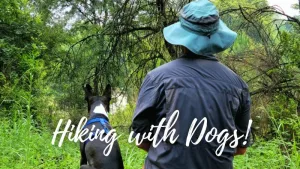
Discover a world of misty mountains, ancient forests, cascading waterfalls, and muddy river crossings on the Magoebaskloof hiking trails.
This is not your run-of-the-mill stroll in the woods — it’s a lush, leg-burning, soul-refreshing adventure through one of Limpopo’s most magical landscapes.
The Ultimate Guide to Hiking in Magoebaskloof
Why Should You Choose the Magoebaskloof Hiking Trails?
Magoebaskloof offers a rare blend of accessible wilderness and off the grid solitude. The trails wind through afro-montane forests, past waterfalls and mountain streams, and offer hikers the chance to see rare and critically endangered birdlife like the Cape Parrot.
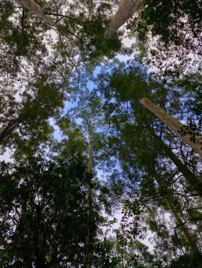
The forests here are more than just a hiker’s paradise—they’re a living archive of South Africa’s early forestry experiments. In the early 20th century, pioneers like A.K. Eastwood and A.J. O’Connor transformed this misty mountain region into a vast outdoor laboratory, planting a variety of exotic tree species to determine which would thrive in local conditions and serve the burgeoning timber industry. The result? A patchwork of plantations featuring pines, cedars, and gums, each section a testament to the scientific curiosity and ambition of that era.
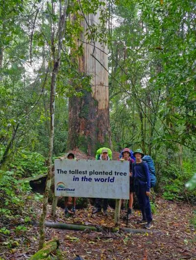
Among these arboreal experiments stands the “Fourth Kin,” a Eucalyptus saligna planted in 1906, now recognized as the tallest planted tree in the world at 83.7 meters. This giant, along with its siblings—the Magoebaskloof Triplets—has earned Champion Tree status, highlighting the region’s unique contribution to global forestry. These towering trees not only represent historical milestones but also continue to inspire awe, drawing visitors eager to witness the legacy of South Africa’s forestry pioneers.
This area is also a birder’s dream, offering some of the best forest birding in South Africa. These misty montane forests are home to an exceptional variety of species, many of them forest specialists rarely seen elsewhere. The critically endangered Cape Parrot is undoubtedly the star attraction—this vibrant green and gold parrot is endemic to South Africa and Magoebaskloof is one of the last strongholds of its dwindling population. Hearing their raucous calls echoing through the forest canopy is an unforgettable experience. (We heard them and saw them flying!)
Alongside the Cape Parrot, birders can look out for the flamboyant Knysna Turaco (formerly Lourie), often glimpsed in a flash of green and crimson as it glides between trees. Other forest jewels include the Narina Trogon, Black-fronted Bushshrike, Orange Ground Thrush, Chorister Robin-Chat, and Yellow-streaked Greenbul. The region is also frequented by raptors like the African Goshawk and Crowned Eagle, while dams and streams attract Giant Kingfishers and African Black Ducks. With a bit of patience (and a good pair of binoculars if you want to carry the extra weight), Magoebaskloof delivers a truly rewarding birding experience.
Things To Look Out For On the Magoebaskloof Trails
- Cape Parrots, Samango monkeys, Bush pigs, slender and water mongooses
- Old growth forest, the tallest planted tree in the world! (Eucalyptus grandis), clivias, moss and lichens
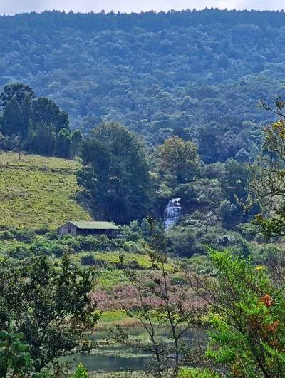
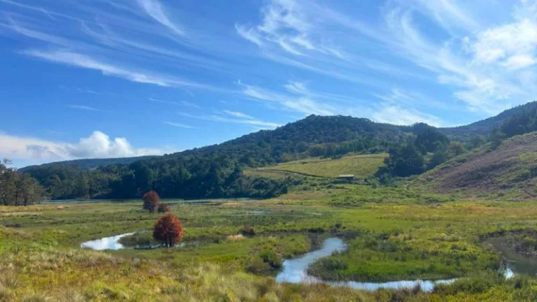
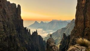
- Stunning views across the Grootbosch, Dap Naude Dam, and picturesque waterfalls including Debengeni Falls
What To Expect From The Magoebaskloof Trail
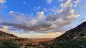
- Misty mountains, towering trees, dense forest and waterfalls
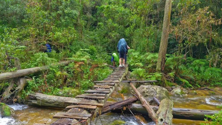
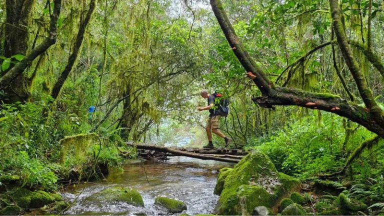
- River crossings with slippery “bridges”
- Rustic huts with charm (and the occasional broken tap)
- Moments of utter peace, silence and beauty
When To Hike the Magoebaskloof Trails
The best time for hiking is April to September (cooler and drier months).
But…expect rain any time of year! Summer in particular (Oct–March) can bring mist and downpours

Average Annual Rainfall in Magoebaskloof

Average Maximum & Minimum Temperatures in Magoebaskloof
About The Magoebaskloof Trails
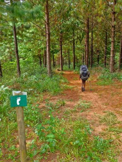
The trail system offers a range of loops and routes through the Komatiland/SAFCOL-managed forests. Routes range from 2 to 5 nights and accommodation is in basic huts scattered across the plantation.
This guide will focus on a 2-night route and a 3-night route. Once you start to go beyond three nights you may start repeating sections of the trail.
Also bear in mind that because a large majority of the routes are circular you can in fact start at any one of the hut clusters.
Trail options range from 2 nights (+-20–25km) to 5 nights (60km+)
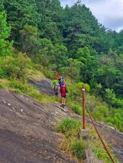
Moderate to difficult depending on the chosen route. Expect some steep climbs and descents, slippery rocks, and technical river crossings.
Moderate to high, depending on the number of days chosen. Some sections are steep and slippery.
You must be able to carry your own backpack for the duration of the hike.
There is no formal limit. Of the 2 groups that walked and contributed to this guide, the youngest was 10 years old carrying his own 35L backpack, and the oldest were 53 with a backpack, and 62 with only a day pack.
Maximum group size: The huts can sleep up to twenty people, but the facilities are limited.
Minimum group size: While there is no official minimum group size, we strongly recommend hiking in a group of at least three. The terrain is rugged, and the trail’s remote nature means it’s best enjoyed — and safest — with company.
These trails currently only offer a self-carry option.
- The benefit with self-carry on these trails is that you don’t need to take a tent or mattress which does make one’s backpack lighter.
We have heard that there might be someone taking over the Slackpacking operation – we will update as soon as we find out.
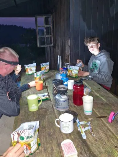
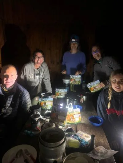
There are six rustic huts, grouped in pairs:
- De Hoek & Dokolewa Pools
- Woodbush & Seepsteen
- Waterfall & Broederstroom
All of the huts have bunk beds and mattresses.
Only two have electricity and hot water (De Hoek, Broederstroom).
All others have no electricity and cold running water only.
There is running water at most huts — however, it’s worth checking in advance.
For drinking we filled up at the numerous rivers and streams along the way with no issues.
- Braai areas at all huts
- This is just a grid. There are no other utensils of any description
- Mattresses and bunk beds
- Cold showers at most huts (hot water at De Hoek and Broederstroom)
- No electricity at Dokolewa, Waterfall, Seepsteen, or Woodbush
- Each hut usually has two bench type tables
- Flushing toilets (but it is recommended to bring your own toilet paper)
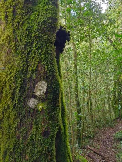
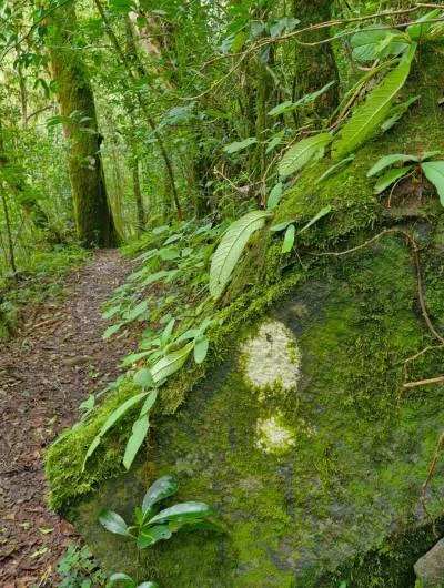
- Trails are not always well maintained
- You will be given a map but we were not convinced of its accuracy (I have not yet managed to find another map of the area)
- Maps.me worked reasonably well for one party of hikers
- Bring your own toilet paper and candles/headlamps
- A 4×4 to reach the three available parking areas is not strictly required, but high clearance vehicles are recommended, especially after rain.
- The gravel roads can be muddy and slippery and not well maintained.
Different Options For The Magoebaskloof Trail
There are a multitude of different options available to you depending on how many days you want to hike and in which order you want to hike the huts.
You can hike loops starting from:
- Woodbush,
- De Hoek, or
- Broederstroom
Choose from 2-, 3-, 4-, or 5-night trail options. Each trail links 2–4 huts and covers different terrain. Some repeat segments are unavoidable on longer hikes.
This guide will focus on a 2-night circular option and a 3-night circular option as the most popular and accessible options.
The 2-Night Route
Day 1: Dokolewa Pools → Seepsteen Mule Stables (+-13 km, ±5 hours)
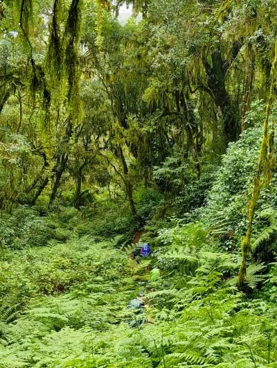
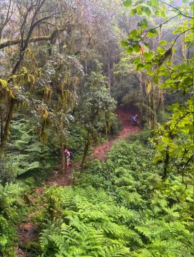
After leaving your car at De Hoek, head downhill toward Dokolewa Pools and the Politsi River. Cross over the wooden “bridge” at Dokolewa Hut and every bend in the trail reveals another river crossing, bank of ferns, or chorus of birds. This is classic Magoebaskloof: damp, dramatic, and deeply peaceful.
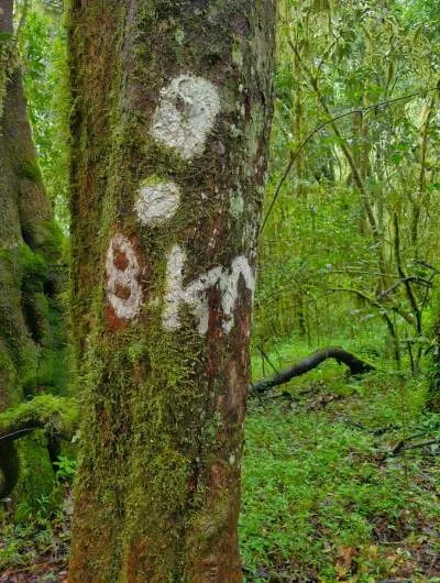
You will pass a tree marked 8km, and the map supplied to you states that the route is 8.5km. Do not be fooled! That tree marking is just plain mean! You still have a way to go.
The trail climbs through indigenous forest into plantation forest before reaching Seepsteen Stables Hut. If the area’s recently been logged, the landscape can feel bare, but look beyond to catch views of rolling hills and forest patches. As always, the indigenous forest is never far away — and neither are the butterflies.
Day 2: Seepsteen → Dokolewa (and on to De Hoek if needed, +-11.5km, 4–5 hours)
Descend through forest and past river cascades. If conditions allow, take a detour to the base of Debengeni Falls — it’s a stunning picnic spot. Dokolewa Hut is riverside bliss — a brilliant place to end your hike with a swim in one of the natural pools. Otherwise, head uphill to De Hoek for the night.
The 3-Night Route
Day 1: De Hoek → Woodbush (+-13km, 5 hours)
Start your hike from De Hoek Hut and descend past Dokolewa Pools, a lush, ferny area nestled along the Politsi River. After crossing several rivers via occasionally dodgy but exciting wooden poles (bridges is a strong term for these!), prepare for a steep climb into the Woodbush area — an old forestry station still without electricity but full of charm. You’ll find running water, bunk beds, and a braai spot. Cape Parrots are sometimes spotted here in the early mornings or evenings.
Day 2: Woodbush → Waterfall Hut (via tallest tree, 14–15km, 6-7 hours)
Leave early to visit the tallest planted tree in the world — a 1906 gum tree towering at over 83m. Once you hit the trail to the giant trees then follow the signs to Broederstroom (even if you’re going to stay at Waterfall hut). The hike continues through glorious Afro-montane forest, past the Dap Naude dam which was built in 1958, and into cultivated areas, with signs of logging juxtaposed starkly against pockets of untouched wilderness. As soon as you are back inside the cathedral of trees, lichen, old mans beard and moss it’s easy to be transported back to feeling that you’re in this epic wilderness. We found the latter portions of the day’s trail slightly less well maintained but we didn’t get lost and still found our way to the hut with ease.
Waterfall Hut lives up to its name — set below a beautiful fall with a very chilly pool perfect for brave post-hike dips. The views stretch across streams and vleis, and while the facilities are basic (cold showers, no power), the atmosphere is magical.
Day 3: Waterfall Hut → De Hoek (+-17km, 7 hours)
Retrace your steps briefly heading back up the trail the way you came. We then followed a sign left that said Dokolewa hut/pools. This little track took us on to a dirt road and then the sign pointed left again. Upon going left however the track at the next Dokolewa sign was blocked off. We tried a variety of routes but ultimately had to do a u-turn and so from Waterfall hut, coming up to the dirt road, take a right and just keep following the road. You can still see Broederstroom hut up to your right. Eventually you will be walking through another avenue and see the white footstep marking on a tree.
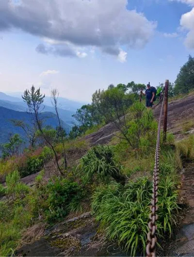
The trail loops around the other side of the hill. This is the most technical day: expect steep sections, granite slabs with chain assists, and some careful footwork.
There are some magical views over Grootbosch until you descend down to the Politsi River and hit where the trail branched on the first day. At that point you continue down along the river back to Dokolewa hut. On to De Hoek where a hot shower and functioning lights await — and hopefully that cooler box of cold drinks in your car.
Current Cost To Hike The Magoebaskloof Trail (2025)
As of April 2025, the rate per person, per night was R223.
SAFCOL did not distinguish between adults and children so everyone paid the same rate.
How To Book To Hike The Magoebaskloof Trail
Contact Komatiland Ecotourism on telephone +27 (0)13 754 2724 or email – ecotour@klf.co.za or ecotour@safcol.co.za
Getting To The Magoebaskloof Trail
From Gauteng, take the N1 north to Polokwane, then the R71 to Tzaneen.
Signposts to the three entrances (Woodbush, De Hoek, Broederstroom) are along the R71.
De Hoek is near Debengeni Falls.
How To Reach The Starting Point Huts of The Magoebaskloof Trail
- De Hoek: Take the gravel road as if going to Debengeni Falls (which are signposted off the R71)
- Woodbush: Turn off from R71 at the Houtbosdorp / Kuhestan sign
- Broederstroom: Take the same Woodbush turnoff and then follow plantation roads as signposted
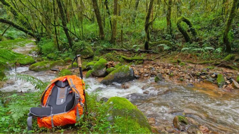
What To Pack For the Magoebaskloof Trail
It can be tough to figure out what should stay and what should go when you’re trying to pack for any hike. Take a look our super handy tips on what to pack for your next trail!
How To Pack For The Magoebaskloof Hike
Packing light and smart is key on the Magoebaskloof trails.
A well-packed backpack can make the difference between an enjoyable hike and an uphill battle. Keeping things compact, balanced, and accessible is half the game.
If you’re feeling a bit unsure about what goes where, here’s a handy guide on how to pack your hiking backpack to help you get trail-ready with confidence.
Don’t Forget To
- Hiking poles are highly recommended for slippery mud and multiple river crossings
- Take toilet paper. We were told that toilet paper would be available in the huts but in fact only 1 hut had toilet paper.
- Take a rainproof jacket/poncho and backpack cover. Magoebaskloof is a wet area with high rainfall – part of which makes it so beautiful.
- Take firelighters – even if you’re not going to braai it’s super to be able to light a fire in the evenings.
- Leave a cooler box with cold drinks in the car for your return!
FAQS
Here are some of the most frequently asked questions about the Magoebaskloof Hiking Trails
Is it family-friendly?
- My answer would be yes as the river crossings, cables and ladders keep the kids interested – however they do need to be reasonably fit.
Can I slackpack?
- At the moment unfortunately not.
Are the huts well equipped?
- They all have bunkbeds and mattresses and braai areas; some have electricity and hot showers, others are more basic.
- Do not expect too much – think rustic and come prepared to be self-sufficient and you will be fine! That’s why we all took Trail Food 😊
Is the trail well marked?
- Mostly, but don’t rely solely on signage or the map.
- We thought the trail was reasonably well marked but not necessarily always well-maintained. The other group of hikers felt that they needed maps.me – as long as you remain aware and don’t split up you should be fine.
What wildlife might I see?
- If you are very lucky you might see some Bush pigs
- Samango monkeys are likely – you should definitely hear them
- A mongoose or two
- And tons of butterflies and birds
Pro Tip!
Let someone else lead the way…they become the spiderweb breaker!

Thank you to Harriet and Trish for photographs.
Please note that this guide is not a SAFCOL guide – it is a guide based on our experience.
If you have an epic hike or trail to share, or if there are any corrections or updates that you would like to suggest to this trail guide, please email

FUEL FOR YOUR ADVENTURES
I'm ready to hike
All our hiking meals are healthy, lightweight, and convenient.
We’ve done all the planning so that you can simply hike!
Ultimate Hiking Guides


Adventure Insights


Featured Products
“Dehydrated Mixed Veggies” has been added to your basket. View basket
-
 Main Meals
North African Couscous with Lamb
R75.00 – R170.00Price range: R75.00 through R170.00 Select options This product has multiple variants. The options may be chosen on the product page -
 Main Meals
Hiker’s Bobotie
R75.00 – R165.00Price range: R75.00 through R165.00 Select options This product has multiple variants. The options may be chosen on the product page -

-