
Giants Cup Hike

If you are yet to explore the Drakensberg on foot, the Giant’s Cup hiking trail should have a featured spot on your bucket list.
This wonderfully scenic trail meanders through the southern foothills of the Maloti-Drakensberg Park World Heritage Site, boasting treasured San rock art and a diversity of fauna and flora.
If you feel intimidated by the prospect of hiking the Drakensberg mountains, rest assured that the Giant’s Cup is well-marked, and someone of average fitness could easily complete this hike in five days.
The Trail Food Co. is also here to make every step of your adventure as convenient as possible with our delicious hiking meals and hiking snacks. If you want a one-stop, healthy solution for all your meals and snacks, take a look at our multi-day packs that contain everything you might need.
Whether you have an adventurous spirit or you’re looking for a fun hiking trip with your friends or family, here’s everything you need to know about the Giant’s Cup hiking trail.

The Ultimate Guide to Hiking Giant's Cup
Why Should You Choose the Giant’s Cup Trail?
The 60-65km trail starts on the Sani Pass at an altitude of 2847 meters, is not overly strenuous, and the scenery makes it one of the most attractive hikes in South Africa.
The Maloti-Drakensberg Park carries World Heritage Site status for its wealth of natural landscapes, the fact that it is home to various threatened and endemic species, and the hundreds of San rock art sites that date over 4000 years. This combination of characteristics is what qualifies the Park to proudly carry this title as one of 23 of these globally protected areas.
You’ll meander through streams, valleys, and remote paths along the foothills of the Drakensberg on this hiking trail. If you’re looking for a relatively convenient way to experience a hike through the Drakensberg mountains, the five rustic overnight accommodation options mean that you don’t have to carry tents.
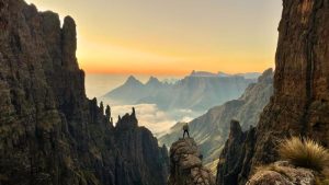
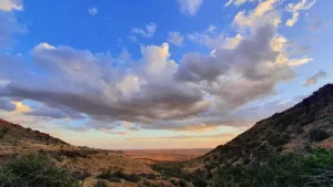
The trail offers breathtaking views of the Drakensberg Mountains, which include some of the highest peaks in South Africa. There are also significant cultural and historical remnants on this trail, as hikers traverse along the land where the San people used to live – and one of the caves along the trail contains their famous rock paintings.
Hikers can look forward to walking through various ecosystems that contain unique plant and animal life on this trail. Some of the ecosystems you can expect to find along your journey include grasslands, wetlands, and afro-montane forests.
Although this hike is not particularly challenging, hikers should be aware that snow can fall in the mountains throughout the year.
If you’re considering hiking the Giant’s Cup trail, you should have some hiking experience and be in good physical shape. It’s always a good idea to be prepared for changes in weather when you’re hiking a mountain trail and to pack plenty of water, food, and other supplies.
What To Expect From the Giant’s Cup Trail
Hikers can anticipate a few steep ascents and descents along the trail, but nothing too strenuous.
Be aware that you are likely to cross paths with fellow hikers on the route. Hopefully, you will end up chatting and making friends with them as we did on our hike.
Things To Look Out for on the Giant’s Cup Trail
As if it’s not enough to look forward to seeing actual San rock paintings, there are also a lot of other things to look out for on your Giant’s Cup trail hike:
- Cranes, Verreaux Eagle, Bearded Vulture
- Spectacular views
- The Langalibalele Cave
- You could see a variety of animals along the trail ranging from Eland to Dassies (Rock Hyrax). Birds are less common at these higher altitudes, but birds of prey, such as the Jackal Buzzard and Verreaux Eagle, may be seen.
- You may be fortunate enough to see the endangered Bearded Vulture or Cape vulture.
- Leopards can occur but are extremely shy, so you’re very unlikely to encounter one.
- We saw evidence of porcupines on our hike.

When to Hike the Giant’s Cup Trail
The climate at these altitudes means that the nights are cool in summer and very cold in winter. As mentioned, snow can occur during any month of the year. You can mainly expect rain in the summer when mist and low clouds are common. Winter and autumn days are usually fine and warm, but the weather can, however, change rapidly. So regardless of when your hike is scheduled, you should always be fully equipped to cope with sudden severe changes in the weather.
There are a variety of factors to consider when deciding when to hike the Giant’s Cup. Firstly, it depends on your personal preference and the conditions during that period. However, the dry season which runs between May and September is usually the best choice.
You can expect the weather to be more balanced during this time, meaning that the trail will be less likely to be slippery or muddy. The days will also be longer during this period, meaning that you have more time to hike.
If you’re trying to avoid wet weather, the winter months ranging between the end of June and August can also be a good option. However, keep in mind that the higher elevation could mean that temperatures will drop below freezing, which could mean snow and ice that will make your hike challenging to navigate.
For those seeking milder weather and beautiful wildflowers in bloom, try to go during spring or autumn (either side of June to August). Although these are the typical weather conditions for spring and autumn, it’s always a good idea to check the weather forecast and trail conditions before your hike.
Afternoon thunderstorms are a common occurrence during the summer months, and hikers are strongly advised to be at their next overnight stop soon after lunch each day. The benefit of this recommendation is that you will have shelter in the event of a storm. If there’s no storm, you’ll have lots of time to enjoy swimming in the crystal clear mountain streams, taking photographs, or relaxing.
We did the Giant’s Cup in mid-December, and the trail was VERY wet, so much so that paths were literally like streams at times. It did rain most afternoons, but we made it to our hut in time on all the days except for the last, when it rained all day.

About the Giant’s Cup Hiking Trail
Here’s all the essential information you need to get ready for the GCT.
It will take you 5 days to complete the trail from the start (Sani Pass) to finish (Bushman’s Nek).
There are 5 different huts on this trail, but you don’t necessarily have to sleep in the final huts at Bushman’s Nek. When we did the trail, we didn’t sleep at the Bushman’s Nek huts and instead decided to get a shuttle into Underberg, where we spent the night.
You can also opt to only do sections of the GCT, as long as you are going from North to South.
Medium / Average
Average to reasonable fitness.
There are no specific age limits. Hikers as young as 7 have completed the hike.
If you’re looking at doing the trail as part of school group activities, at least one adult must accompany each group of up to 10 persons who are under the age of 18.
The trail is self-carry only, and tents are not required. Hikers should carry some sort of sleeping mat or a mattress, as the Mzimkhulwana hut does not have any mattresses.
There are 5 huts along the route.
Pholela Hut
- The old farmhouse sleeps 30 people in bunk beds in four bedrooms.
- Two of the rooms have built-in fireplaces.
- The hut has electricity and hot water (load shedding dependent).
- There is a toilet and a basin.
- It also has 2 showers and another basin.
- There is a verandah and a covered braai area in front of the hut.
- This hut is the busiest of all the huts along the route because other hikers accessing trails from Cobham can also use it.
Mzimkhulwana Hut
- The hut has 5 rooms next to each other, with three bunk beds in each room.
- This accommodation does NOT have any mattresses, so hikers should carry camping mats or mattresses.
- An open area between the rooms serves as a kitchen – really just some benches and a concrete slab to be used as a table
- A small ablution hut further upstream offers toilets, cold water showers, and hand basins.
- The setting is very picturesque, nestled into the foothills.
- There is a gorgeous pool a little way from the hut which is great for swimming.
Winterhoek Hut
- The hut consists of eight rondavels set amongst oak trees.
- Five of these huts have three bunk beds each.
- One rondavel serves as a kitchen, while another serves as a bathroom with cold water showers.
- It’s in a spectacular setting against Garden Castle and the valley.
- Hikers may also swim in the small pond above the dam.
- There is no electricity or hot water.
Swayiman Hut
- A large old forestry house
- It has three bedrooms with four, four, and six bunk beds, respectively.
- There are toilets and showers.
- The hut has electricity and hot showers.
- The veranda offers a good view of Swayiman peak.
- There is a kitchen and a lounge with a fireplace*
*It started pouring with rain and then even hailed the afternoon when we reached the Swayiman hut. So we started a fire, which was divine. See the Pro Tips section for more information.
Bushman’s Nek Hut
- The Bushmans Nek hut is similar to the Mzimkhulwana hut in that it has five rooms that adjoin one another.
- The toilets and cold water showers are located between the rooms.
- There is no electricity at this hut.
- To reach the police station and the parking lot, hikers follow a path below the huts. It is approximately a 15-minute walk.
How does one get water along the route?
All of the huts have running water, but it is also safe to drink water from the streams and rivers in the higher reaches of the Drakensberg.
Do you need to take water purifying drops or a water purifier?
From our own experience, we don’t think it’s necessary, but at the end of the day, it comes down to personal preference.
At any one hut a maximum of 30 people can be accommodated.
The only place where you might genuinely have a problem is Pholela because the hut is also used by hikers on routes other than the Giant’s Cup.
Ezemvelo were always very good and clear with us and our booking.
- It’s worth reading the day-by-day sections because there are often little side trips like caves and pools etc., that you will miss if you just follow the GCT markers.
- Hikers must stay on the marked route at all times in groups of not less than three people.
- The receipt printed on your confirmed reservation advice form will serve as your official permit for the hike, and hikers must produce this permit for inspection if required.
- You may only start your hiking trail at an official starting point.
- Hikers are not allowed to camp or erect tents away from the trail huts.
- Hiking is only allowed in the direction indicated on the map and as shown by the trail markers (N 🡪 S).
- At each hut, hikers are requested to use only one mattress when staying in trail huts.*
*The Mzimkhulwana Hut (on the second night of the trail) does NOT have any mattresses.


Different Options for the Giant’s Cup Trail
It is only possible to hike the Giant’s Cup Trail in one direction (Sani Pass heading towards Bushman’s Nek). You can, however, decide to hike the trail in sections, meaning that you don’t have to hike the full 5 days all at once.
The Giant’s Cup hiking trail is well-demarcated with route markers, which is a white footprint placed on trees, rocks, or poles. The trail follows the direction in which the “toes” of the footprint point.
You’ll notice erosion barriers (wooden poles) placed on the trail in many places along the route to channel water away from the paths. These erosion barriers are often hidden under grassy tufts, so be aware of them to ensure you do not trip over them.
Day 1 - Sani Pass to Pholela Hut in Cobham: 13.3km
You can expect to hike this section of the trail in approximately 5-6 hours with stops included.
The trail starts about 5.6km past the Sani Pass Hotel on the Sani Pass Road. Look out for a Giant’s Cup trail sign on the left of the road, which marks the starting point.
From the 3.7km mark, there is a good view of the Giant’s Cup – which is the inspiration for the trail’s name. The Giant’s Cup itself sits in a saddle between the twin Hodgson’s Peaks within the high Drakensberg.
From here the trail drops into the Gxalingenwa Valley. When you reach the narrow valley, strewn with boulders at 4.5km from the start of the trail, you’ll find the Ngenwa Pool, which is a refreshing, small, natural pool within the Gxalingenwa stream.
However, be very cautious along this section when it’s wet or raining since there is a steep descent down to the pool and the crossing. On a sunny day, this is an ideal spot to stop, rest, and have a swim. If you’d rather keep hiking, there are a few more pools a short distance upstream. The water in the Gxalingenwa stream is drinkable, just like most of the water in the higher reaches of the Maloti-Drakensberg Park.
You’ll cross the stream via a wooden bridge and continue to follow the white footprint trail markers. The trail continues left along Ndlovini Hill on the other side of the Ngenwa Pool. Next, a 300m climb will take you to a cave within boulders and trees that hide a large open area through which the hiking path passes (however, we don’t recall seeing this on our hike).
Once you reach the 5.6km mark, the trail crosses a grassland that is rich in Watsonia, which resembles a wonderful orange floral carpet in spring. From the 8.3km point, the trail continues across a sandstone shelf, and once you reach the far end, you’ll be able to see the Pholela hut in the distance.
Next, you’ll walk along the valley floor where the trail crosses a tributary and then the Troutbeck stream at 10.5km (you may have to boulder hop or wade the Troutbeck several times).
Follow the trail markers that will lead you to the swing bridge at 13km to get to the Pholela hut. The trail will lead through the campsite towards the hut, which you’ll be able to identify by the sprawling verandah.
Once hikers drop their bags at the hut, they should remember to report their arrival and fill in the Mountain Rescue Register before continuing with the hike. Hikers can find the Register at the Cobham campsite and reception office, which is about 500m from the hut (it’s located 500m to your left when facing the hut).
The small shop at the office also offers a limited selection of cool drinks and snacks.
Day 2 - Pholela Hut to Mzimkhulwana Hut (Garden Castle Section): 9km
Hikers can expect to walk approximately 3.5 hours with stops or 2.5 hours without stops.
When leaving the Pholela hut, hikers should head diagonally left towards a horse paddock. Look for a sign that says “Giant’s Cup Second Day,” which points towards the Pholela River. The path will wind alongside the paddock until you see the familiar white footprint markers after about 100m that will lead you up a slope to the left, away from the river.
You’ll encounter some stone steps that will lead to the left, where the trail curves uphill and provides a lovely view of the Giant’s Cup. After 3km, the trail crosses a plateau that heads towards the Siphongweni Ridge.
If you look carefully, you can see a group of large sandstone boulders in the distance, known as Tortoise Rocks. The trail continues by winding through a Protea woodland, and you’ll find flat rocks that look out over the valley, which make a perfect place to rest and take a break.
At the 7.2km mark, the trail crosses a small stream. The Mzimkhulwana hut is just 300m from here, which you access via a rustic bridge that leads you over the Mzimkhulwana River.
Since the distance covered on this day is quite short and done in only a few hours, there’s lots of time to have fun exploring around the hut. Hikers can sunbathe on the rocks above the hut or swim in the large pool in the Siphongweni River, which is about 30m downstream of the bridge.
Day 3 - Mzimkhulwana Hut to Winterhoek Hut (Garden Castle Section): 12.2km
You can expect to hike for about 4-5 hours on this day with your stops included.
Hike back along the Siphongweni River without crossing it until you find a wooden swing bridge over the Mzimkhulwana River (the river was pumping when we crossed it). Then head up Bamboo Mountain. After 3.5km, the path will pass Crane Tarn, which is a small mountain lake where you might be lucky enough to see either Crested or Blue Cranes (we had a swim here along our hike but didn’t see anything too exciting).
The two Bamboo Mountains are named after the endemic Drakensberg bamboo that grows in the area. There is a lovely view of Garden Castle looming over the valley when viewed from the ridge on little Bamboo Mountain. The Winterhoek huts lie at the foot of the peak under some oak trees.
The trail continues by meandering downhill on the other side of Crane Tarn and leads through Protea woodland down to the Killiecrankie stream, named by Scottish settlers.
After about 1km, you’ll encounter a fork in the trail. The left fork leads to the Killiecrankie pool. About 100m below the main pool, there is a small waterfall next to a huge boulder, and there are smaller pools close by, all of which make for good swimming spots.
The right fork is a continuation of the main route of the Giant’s Cup. You’ll eventually reach a stile where you will enter private land. The trail continues across a second stile, where you will pass some trout dams and a farmhouse.
Head over another stile, and the overflow from the trout dams another 100m further on. Continue across the track that leads to the farmhouse and follow the stream downhill until you reach the main tarred road from Underberg to the Drakensberg Gardens.
When you reach the main tarred road, you might be lucky enough to come across Cindy and her mobile coffee shop. We highly recommend making a pit stop here to enjoy a delicious coffee!
You can now either decide to head straight for the Winterhoek huts (a) or to first pop in at Castleburn for a well-deserved drink (b).
Take me to my hut!
- Continue to follow the road to the right for 1.7km. Soon after crossing the river, you’ll see a Castleburn Lake sign and the trail markers that indicate that you need to head left over a small hill. Once you get to the other side of the hill, the trail will lead through two gates, and you will cross a stream that flows below a small concrete dam to reach the Winterhoek hut.
To Castleburn for a drink please!
- Continue along the road toward the Castleburn Lake Resort. Head through the gate and take a left towards a few small dams. Pass the small dam to reach the restaurant and pub. To get to the Winterhoek huts from here, you will walk back to the Castleburn Lake entrance, take the cut road on your right and walk through the fields on this slightly flatter route to get to the Winterhoek huts.
Day 4 - Winterhoek Hut to Swayiman Hut: 12.8km
Hikers can expect to spend approximately 6 hours hiking the trail with stops and about 4.5 hours without stops.
The trail winds along the slopes of Garden Castle and along a ridge crest on this day. The route will take you through typical Highland scenery with wildflowers in spring and summer, and you’ll hike along Black Eagle Pass, which offers a wonderful view of the Drakensberg escarpment.
Try to carry some extra water on this particular stretch of the hike.
You’ll start your trail from behind the rondavels and follow the path as it winds up a steep stretch that leads to Black Eagle Pass below the peaks of Garden Castle. Keep an eye on the sky here, as this area is the breeding and feeding range of both the Verreaux Eagle (formerly Black Eagle) and the Bearded Vulture.
The trail meanders across the plateau at a fairly consistent altitude of about 2000m, which will give you birds-eye views of the Mlambonja River on your right and the Mzimude River on the left.
Hikers will walk through Protea woodlands and will eventually see the Drakensberg Gardens Hotel amongst some pine trees in the valley on the right. On the left, a bit further ahead is the Ezemvelo KZN Wildlife Garden Castle outpost, which is where the Swayiman hut is.
Follow the trail above a small waterfall from where you’ll be able to see the hut nestled between trees with silvery hues.
Once you reach a T-junction marked by a stone cairn, bear right for 1km until you reach the Swayiman Hut. Take note that if you hike the Swayiman Hut to Bushman’s Nek stretch the following day, you will pass the same point. However, you will need to bear right on the route to avoid looping back towards the Winterhoek hut.
Remember to report your arrival at the Garden Castle outpost office, which is about a 10-minute walk away. When you head out of the front of the Swayiman hut, you need to go in a diagonally left direction until you reach a pathway (this may be mown during certain times of the year).
Once you encounter a split in the road, keep right until you cross the Mashai River over a small bridge (don’t turn left on the split road since this leads to staff accommodation). Walk through the woodlands to reach the office to sign in.
In the Giant’s Cup visitor’s guide, it mentions that the Garden Castle office sells some drinks, sweets, and other refreshments. However, this is no longer the case, as there was nothing available for sale there during our hike. If you need anything at this point, you will need to walk about 3 to 3.5km to Drakensberg Gardens Resort.
Day 5 - Swayiman Hut to Bushman's Nek: 12km
You can expect to walk between 4-5 hours on this part of the hike with your stops included.
Retrace the same route on which you came in to get to the Swayiman hut until you reach the rock cairn. The path will fork, and you should take the path to the right.
This final stretch of the Giant’s Cup trail heads up a ridge and descends into the valley of the Mzimude River and to Langalibalele Peak. You might notice an old forest fire lookout tower when the conditions aren’t misty or rainy.
There are several high peaks along this area to help orientate you:
- Mlambonja
- Wilson’s Peak
- Mashai
- Mzimude
- Walker’s Peak
- Devil’s Knuckles
You will pass a secondary trail that branches off the GCT and heads to the Hidden Valley.
After crossing the Mzimude River, keep right and make your way towards Langalibalele Peak and the saddle on the right of the peak. You can also access the Langalibalele Cave, where there are San paintings, some of which are faded from exposure to the sun. There is also a small waterfall that flows over the front of the cave (which could be dependent on the season of your hike).
At the 11.8km mark, you will reach a junction with a sign that points towards the Bushman’s Nek hut to the right, which is about a 10-minute walk.
If you go left at the junction, you will get to the police station, which is about 1km from there.
At this point of the trail, you can either overnight at the Bushman’s Nek trail hut and then drive back to Himeville the following day. Or you can opt to stay in the nearby Bushman’s Nek Hotel.
Remember that you need to sign the Mountain Rescue Register at the Ezemvelo Wildlife office to indicate that you have completed the hike and that you are out of the mountains.


Current Cost to Hike the Giant’s Cup Trail (2024)
All rates include a community levy and an emergency rescue levy. Any hikers aged 12 years and older will be charged adult rates. As of 2024, the rates are R130 per person per night. Keep in mind that costs may vary depending on seasonal rates.
Remember that the receipt on your confirmed reservation advice form is your permit for the hike, so you should always have it with you.
How to Book the Giant’s Cup Trail
Here’s everything you need to know on how to book to get those itchy feet on the GCT. There are various ways to book, but judging from our own experience, we’d recommend emailing or phoning them.
Contact the Ezemvelo KZN Wildlife Central Reservations Office (in Pietermaritzburg):
Email: bookings@kznwildlife.com
Tel: +27 (0)33 8451000
Online bookings: https://bookings.kznwildlife.com (We found the process confusing and would not recommend booking your hike this way – but that may well be just me!)
Website: http://www.kznwildlife.com/GiantsCupTrails.html
Customer service: customercare@kznwildlife.com
We made our booking over the phone and via email. The Ezemvelo staff were very helpful, and we received a reservation email promptly following our call. The Reservation Advice email contains information for payment by credit card or direct deposit.
Credit cards and direct bank deposits are the preferred methods of payment. They no longer accept cash payments and cheques.
You’ll be asked to complete and return a form should you want to pay by credit card or email the details with your reference number to creditcards@kznwildlife.com
If you want to pay by bank transfer, the details are as follows:
STANDARD BANK, KINGSMEAD,
Branch Code: 051 001
Account Number: 051 130 270
Account Name: Ezemvelo KwaZulu Natal Wildlife
Swift Code: SBZA ZA JJ
You MUST email copies of the slips for payments/proof of payment into their account, reflecting your reference number, to banking@kznwildlife.com, or you can fax it to 086 5058893.
NB! If you don’t submit proof of payment to the correct email address at Ezemvelo, it will result in your booking getting cancelled.
We paid via EFT and had no issues.
Ensure that you make your booking in advance to allow enough time for the payment to get processed. Mention how many people will be in your group and clearly indicate the number of adults and children. You have to state each overnight stop you plan to have on your route, and you need to book a minimum of two huts.
Getting to the Giant’s Cup Trail
From the N3
If you’re travelling on the N3 highway:
- take the R617 from the Howick South/Underberg off-ramp (marked exit 99).
- Follow the R617 through Bulwer towards Underberg.
- When you get to Underberg, take a right onto the R315 towards Himeville.
- About 2km past Himeville, turn left onto the P318 towards Sani Pass. Although this is a gravel road, it is accessible in all types of weather.
- Stay on this road for a further 3.5km past the Sani Pass Hotel, which will be on your right, approximately 9.5km from the Himeville turn-off.
The trail starts on the left-hand side of the road when you’re at the Ezemvelo KZN Wildlife Makhakhe Field Ranger Outpost car park (about 5.6km from the turn-off). The South African border post with Lesotho is about 15km from the start of the trail.
Only people with 4×4 vehicles are allowed 6km up the pass beyond the SA border post to the Lesotho border. You will need a valid passport to enter Lesotho.
Please note: Only those who have made prior arrangements are allowed to leave their vehicles for the duration of their trail at the Ezemvelo KZN Wildlife Makhakhe Field Ranger Outpost. Since the trail is not a circular route, hikers will need to arrange to return to their vehicles at the end of the trail or leave it at the point from which they exit the trail.
Those opting to overnight at the Sani Backpacker Lodge or the Sani Pass Hotel can arrange in advance to be driven to the start of the trail to get back to their cars.
It’s also a great idea to either pop into Lesotho before or after your GCT hike for a drink at the highest pub in Africa at the Sani Mountain Lodge!

Transport to and from the GCT
You are responsible for your own transport to the starting point, and from the end point back to your vehicle.
If you overnight in Underberg or Himeville, you can arrange to be driven to the official start of the trail on the Sani Pass. However, make sure you arrange this in advance.
If you spend the night before at the Sani Pass Backpackers, then instead of setting out at the official starting point, follow the Gxalingenwa Trail from the Backpackers. This route joins the GCT at around 4.25km.
When we completed the GCT, we used the Southern Berg Shuttle service. They were exceptionally responsive, and you can make your booking with them before you start your hike. We ended up calling on the last day, and they were extremely accommodating, given the late notice, and organised a trailer for all of our bags. We can definitely highly recommend them.
You can reach Xolani or Cedric at:
Cell: 072 325 4267 or 066 359 4912
Email: bergshuttle@gmail.com
We paid R200 from Bushman’s Nek to Underberg/Himeville.
What To Pack for the Giant’s Cup Trail
Do you need some pointers on what to pack for the GCT? Take a look at our helpful tips on what to pack for your hiking trail!
Here is some additional information on packing meals for multi-day hikes.
How To Pack for the Giant’s Cup Hiking Trail
Trying to figure out how to pack your backpack for a multi-day hiking trail can feel overwhelming. We’ve simplified it into five steps to help you pack your hiking backpack.
Don’t Forget To
Here are a few things to keep in mind on the GCT:
- Complete the requisite Mountain Rescue Registers at Cobham, Swayiman, and Bushman’s Nek. These are typically accessible at all hours of the day. Ensure that you fill out all the required information. You’ll notice a tear-off slip with emergency numbers – take it with you and keep it in a dry, safe place.
- Cellphone reception can be erratic, but it is a good way to report an emergency. In the event that you don’t have network reception, one or two members of your party should quickly make their way to the nearest Ezemvelo Wildlife outpost to report the emergency.
- Remember to sign out at the Ezemvelo Wildlife office closest to your point of exit so that the staff are aware that you have safely completed your hike. Should you forget to do this, it could result in costly and unnecessary use of a search and rescue operation, and you could be held liable for the costs.
- Buy detailed maps at the Ezemvelo Wildlife office at Cobham. Each group should typically carry copies of maps 5 and 6, which cover the entire route of the Giant’s Cup trail.
Pro Tips
Here are a few extra pointers to ensure you’re fully prepared.
- Take toilet paper! Sometimes the huts have toilet paper, and sometimes they don’t, so make sure you carry your own and enough, as there is nowhere to get more! You’ve been warned 🙂
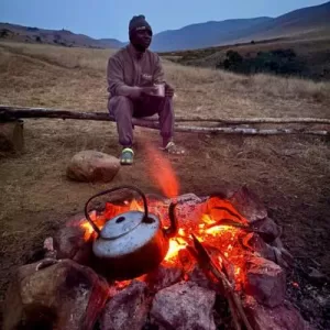
- Take a small pack of firelighters. These were just the ticket for when we lit a fire on our second-to-last night at Swayiman’s hut. It wouldn’t have been possible without them. Interestingly, an amount of firewood was supplied, which was really nice.
- If you are using cook-in bags from Trail Food Co., then you probably only need two cookers/jet boils per group of 4-6 people, which cuts down significantly on weight.
- Download the Gaia GPS app. It has free and paid versions and provides good details about things to look out for on the trail, such as caves and waterfalls.
An Important Note
The San rock art is present along many places at Garden Castle and Cobham. It goes without saying that these paintings are irreplaceable glimpses into the past. Should you wet these paintings, it will reduce their lifespan. Any disfigurement of these paintings is a serious offence punishable by law.
Hikers are not permitted to pick any wildflowers or vegetation in the Maloti-Drakensberg Park due to it being a World Heritage Site, and fires are only allowed in designated areas.
Final Thoughts
The Giant’s Cup Trail is a phenomenal way to explore and experience the Drakensberg mountains for people with average fitness levels. If you want to go on a family hike or with a group of adventure-spirited friends, you should seriously consider this trail.
Our Trail Food Co. meals are ideal for this self-carry hike, and you’ll get to tuck into hearty, healthy, and delicious dinners every night without any meal planning! Take a look at our Lightweight Pack if you want to travel light, or the Gourmet Pack if you don’t mind carrying a little extra weight around to enjoy the small luxuries. If you simply want to enjoy our super convenient Pack Bag, we now also have the option to purchase them separately.
The Giant’s Cup Trail Map

If you have an epic hike or trail to share, or if there are any corrections or updates that you would like to suggest to this trail guide, please email

FUEL FOR YOUR ADVENTURES
I'm ready to hike
All our hiking meals are healthy, lightweight, and convenient.
We’ve done all the planning so that you can simply hike!
Ultimate Hiking Guides


Adventure Insights


Featured Products
-
 Main Meals
North African Couscous with Lamb
R75.00 – R170.00Price range: R75.00 through R170.00 Select options This product has multiple variants. The options may be chosen on the product page -
 Main Meals
Hiker’s Bobotie
R75.00 – R165.00Price range: R75.00 through R165.00 Select options This product has multiple variants. The options may be chosen on the product page -

-